Stephanie Bricker, Urban Geoscience team leader at the British Geological Survey describes how BIM approaches can help unlock the potential of the ground beneath cities…
The geological sciences have an important, but often under-appreciated part to play in securing sustainable global cities and can support urban innovation and city performance, reduce our environmental footprint and ensure we are resilient to natural hazards such as flooding and ground instability.
At the heart of this approach lies a ground information ‘model’ which allows us to understand and manage the multiple and complimentary uses for the ground beneath our cities to avoid potential conflicts and competition for space and function.
The British Geological Survey (BGS) has been at the forefront of the scientific and technological development of 3D city ground data management and modelling. These spatial data products and 3D modelling services are used to assess geo-hazards and difficult ground conditions across the environmental, planning and insurance sectors. By making this information available at an early stage, in a digital and inter-operable format, ground investigations can be better planned and buildings and urban infrastructure can be designed more appropriately. For example, BGS constructed a high-resolution geological model of the Crossrail Station at Farringdon in London, particularly focusing on where geological faults may occur. Understanding the faulting pattern enabled the engineers to predict the potential occurrence of water-filled sand bodies, which are hazardous if excavated. During excavation, the geological model was validated and updated frequently. The outcome – an improved understanding and recognition of a complex faulted area, which led to an optimised ground investigation and an improved understanding of risks for construction, resulting in a better design and, ultimately, improved estimation of final costs.
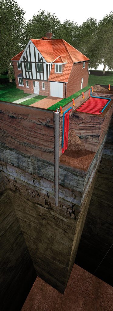
Ground source heat pump systems utilise the ground to provide heating and cooling for buildings
The use of data management and information modelling to reduce whole life costs of infrastructure projects is particularly important. Development can be carried out in almost all locations but there is a need to take ‘permissible risk’ into account; that is, to be aware of the costs of development and mitigation from the outset. Difficult ground conditions are more manageable if they are anticipated, and if there is sufficient money, technology and expertise to deal with the problem and if the land provides sufficient economic return to warrant additional investment. However, unforeseen (difficult/adverse) ground conditions remain problematic and are a significant source of project overruns and overspend. Insufficient understanding of subsurface ground conditions is generally recognised by the construction industry across the UK and Europe as a key factor in overspending, project delays, and overly conservative design.
New digital data technologies, open data policies and inter-operable BIM approaches bring opportunities to sync 2D, 3D and 4D geological and environmental data with building information across multiple spatial scales. With this, there is increased potential to define the geological and environmental hazards that may impact on our development but also to understand the dynamic environmental setting within which the development lies. There is growing appreciation that our built environment can be more intimately linked with the functions and services that our natural environment provides. To what extent can we increase the economic return of the ground beneath our cities for example, by greater utilisation of ground heat in our buildings, better matching building design with local building materials, or by using the ground to store water and filter greywater? Where the current geoscience approach to infrastructure development is centred on hazards and constraints, the future focus should be one of geological value, opportunity and optimization. To facilitate enhanced 3D and 4D BIM approaches and integration of geo-environmental information we, as an environmental community, need to work towards open data standards, flexible data licensing policies, network based client server models and live web-services. In this way, we can maximise the extent to which geo-environmental data is collected and shared but we ensure that domain experts retain ownership of, and responsibility for, the data and models.
Dr Kate Royse
Science Director or Environmental Modelling
British Geological Survey
k.royse@bgs.ac.uk
Please note: this is a commercial profile


