Cities are sitting on useful planning data. They must learn how to make use of this, says Stefan Webb, Head of Projects at Future Cities Catapult
Big data, artificial intelligence, and visualisation are transforming the way that people process and interpret information. And more and more frequently, we are seeing that data and technology is being incorporated as part of modern infrastructure planning.
The UK Government’s Industrial Strategy consultation lists innovation and improving infrastructure as key priorities. However, whilst we are seeing first-hand the benefits of applying big data and IoT to the next generation of infrastructure, the methods used by many cities to plan new developments creak with age and smack of desperate inefficiency.
The processes in place within city authorities to gather information about sites, compare proposals from developers, and engage with citizens are certainly rigorous, and produce huge quantities of data at no small expense. If sufficiently determined, you can find it in the appendices of local plans, but as well as finding it hard to understand, you’ll also see that it’s locked up inside PDFs that are difficult for machines to search and analyse.
In the offices of architects and developers who bring those developments to life, things look a little different. There, before bricks or steel are even considered, data, models, and digital maps are used to explore sites, proposals, and plans in exquisite detail. Crucially, these organisations have come to realise the value of maintaining easily accessible data, which they can draw on quickly, easily and repeatedly.
Comparatively, the cost of generating data to support local plans is increased when local planning authorities have to commission new studies, time after time, to obtain the same evidence. And because the evidence will be stored in a PDF it can’t easily be used to inform other services.
For example, many of the datasets collected as part of a housing market assessment are the same as those which inform a community infrastructure levy, a strategic housing land availability assessment, or an infrastructure capacity assessment. But, bewilderingly, the information for these four studies is all procured separately. And any synergies or interdependencies that do occur between the four are managed by human hand: so the process is slow, with errors and loss of fidelity throughout the process.
The problem is exacerbated when different city departments commission their own data-driven exercises to understand, say, the demand for school places, pressure on GP services, or where new job opportunities will be arising in the near future. Data from planning documents could easily be re-used to help provide such insights, but instead it’s gathered once more at high cost.
How to utilise data
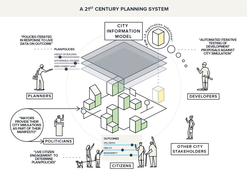
What’s needed, then, is for cities to hold their spatially relevant data in one place, where it can be used over and over again, not just for multiple plans but across departments. Such a system would not just provide efficiency savings by reducing the cost of updating the evidence base for local plans, but also ensure that everyone is working with the same figures and assumptions, making it easier to build tools to access, interpret, and analyse the data.
It was these frustrations and realisations that led Future Cities Catapult to start our Future of Planning programme, focusing primarily on how we plan, rather than what we plan for. People often grumble about the planning system and how difficult it is to change, so we set out to break the silos that divide and delay processes.
Part of our ambition is to create the critical space to experiment; allowing people in the planning space to think how things could be done differently, and, exploring how user focused design, data and digital innovation can improve the UK planning system. Evidence shows that when you give those involved in the system time to think about improvements, they have plenty of ideas.
And that’s why we launched a £200,000 funding Open Call for SMEs and Local Planning Authorities, supporting the development of new tools and innovations to transform the planning system. Winning proposals include using data to identify land for housing developments, managing the impact of new developments on school and GP capacity, and augmented reality to allow citizens to see future developments by holding up their phone or tablet.
By working with the winners of our Open Call to develop and test prototypes, we’ll build a faster, more transparent and equitable planning system. And a city data environment that functions in this way will allow local authorities to maximise the value of the data that is generated as part of the planning process. In turn, it will reduce the time it takes to produce local plans, and make them more transparent and understandable to citizens and developers.
The data is there to be used—cities just need to realise their potential in order to make full use of it.
For more information on our Future of Planning project check out our website or join the #FutureOfPlanning conversation on social media.
 Stefan Webb
Head of Projects
Future Cities Catapult


