
The UK’s efficient pandemic response demonstrated the power of location data as a strategic national asset and to tackle coordination challenges when used, shared and reused effectively, says Chris Chambers, deputy director of NUAR delivery at the Geospatial Commission
As the government’s priorities for the UK advance in opportunity, urgency, complexity and global reach, it is no coincidence that the demand for location data is increasing.
As the UK’s policy agenda focuses on economic growth, environmental sustainability and social opportunity, delivering through key strategies, such as levelling up and net zero, location data is increasingly at the heart of decision making. These strategies require systems-based policymaking, with spatial considerations and location data central to their development, effective implementation and evaluation. The transformative vision that the Geospatial Commission set when we published the UK’s Geospatial Strategy in 2020 continues to evolve.
In June, we published our annual plan outlining the work we have undertaken over the last year, including the first coordinated assessment of the UK’s geospatial data assets against FAIR data principles, initiating a National Land Data Programme to demonstrate the value of enhancing the UK’s spatial modelling capability to inform land use scenario planning, and announcing an intention to introduce a new legislative data sharing gateway to enable property attribute data held by the Valuation Office Agency to be made more accessible to the public and private sector. There are many more examples of our achievements in the last year that I could have mentioned but I am proud of our progress to date.
Growing use of location data to support levelling up
Our annual plan also reflected on the growing use of location data as a strategic national asset to support levelling up, help meet net zero targets and drive science and technology innovation. Location data allows policymakers to consider macro to hyper-local issues at a geographic level; it informs national and local-level planning and decision making. Effective use of location data can help target investment into commercial geospatial innovations across the UK, improve the opportunities for our towns and high streets, grow our regional skills and capabilities, and support the UK’s transition to a greener society.
What does the Geospatial Commission do?
The Geospatial Commission works closely with teams and organisations across the UK to make sure the opportunities provided by effective use of location data are seen and understood by all. In the next year we intend to identify opportunities for location data to improve the UK property ecosystem, publish insights from the local authority electric vehicle location data discovery project we launched earlier this year, and to continue to roll out the National Underground Asset Register (NUAR).
We are excited that together with our delivery partner, Atkins, and its supply chain – Ordnance Survey, 1Spatial and GeoPlace – as well as the Greater London Authority and Welsh Government, we are now working with utilities, telecoms, public sector bodies and other owners of underground assets from across the UK to deliver NUAR.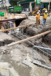
Over 130 organisations across energy, water, telecoms and public sector have already signed up to NUAR by entering into a Data Exploration Agreement (the initial data sharing agreement which enables the NUAR team to access and map their data, prior to it being ingested into the NUAR platform). Nearly 50 organisations have also signed the Data Distribution Agreement (the enduring agreement allowing NUAR to share their data with third parties on an ongoing basis).
NUAR met the Alpha Service Assessment requirements in July
We also received the good news in July that NUAR has met the requirements for the Alpha Service Assessment. This means a cross-government group of digital specialists think NUAR is a good service ready to move to the test stage and be rolled out to a limited cohort of real users. This will give us more feedback and help to maximise the value of the service. This is another milestone on our journey to the platform eventually being operational in Wales, north-east England and London in March 2023, and Northern Ireland and the rest of England in September 2024.
NUAR is just one of the Geospatial Commission’s priorities that reflects how the opportunities for location data can only be fully realised with the support of the private, public and third sectors. Nurturing closer collaboration and coordination between different users of location data is essential if we are to continue to better use, share and reuse location data in new ways to make our everyday lives easier, provide public benefits and respond to global challenges. I am excited about how location data is delivering positive change and what more is to come.
Chris Chambers
Deputy director of NUAR delivery


