Introducing Focus i.1, Focus i.1 X, and Rovi i.1 from FARO INSIGHT
Visit a major construction project today and reality capture is likely to be part of its workflows. It may begin with static laser scanners accurately documenting existing conditions before breaking ground, continue with mobile mapping systems tracking progress during construction, and post-construction data supporting retrofit planning and providing accurate digital records at handover.
However, for many project teams, the challenge is shifting from simply capturing those realities to making the information dependable, contextualised, and accessible. On complex projects, tight margins and expectations for long-term records make that challenge especially important.
In response, digital reality is moving into everyday operational workflows that support planning, construction, and asset management. Accelerating that shift depends on three things: capturing the detail teams can trust, positioning that information within the wider project, and making current site conditions digitally accessible to more people.
Building confidence in the data behind every decision
Design teams, quality managers, retrofit specialists and asset owners all work from the same assumption: that the digital representation in front of them is a faithful account of the physical site. As projects move from one phase to the next, that confidence in the underlying data becomes essential for making decisions with certainty.
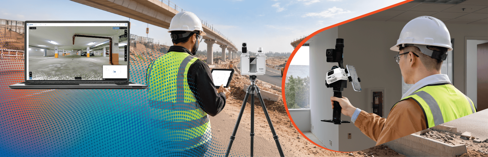
The Focus i.1 Terrestrial Laser Scanner is designed to give teams precision and accuracy for greater confidence in the detailed site data behind their decisions. When teams are validating existing conditions or investigating construction deviations, the detail, integrity and scanning repeatability of the site matters. The scanner’s improved accuracy and performance meet that need with colour scans captured in around 20 seconds per scan position, helping teams collect richer information in less time.
While accurate capture builds confidence, speed turns that confidence into action sooner. With the Stream™ App, teams can review scans on site and upload them directly to FARO Sphere® XG for cloud processing, simplifying the path from capture to deliverable so up-to-date information reaches the right hands at the earliest.
Positioning reality across larger environments
Data becomes considerably more valuable when teams know exactly where it belongs in the real world. On large construction and infrastructure projects, reality capture rarely exists in isolation. For the best precision and accuracy, point clouds or images need to align with project coordinates; this is where georeferencing plays a key role.
The Focus i.1 X adds to the functionality of the i.1 by connecting captured reality to its real-world location through a mountable GNSS/RTK receiver that supports real-time georeferencing. That, combined with additional scanning range of up to 400m, helps teams capture larger outdoor sites and position the resulting information within against real-world coordinates.
By linking design, survey and asset data to precise geographic coordinates, construction professionals can reduce errors, monitor progress and ensure construction activities align with site conditions and project requirements.
Making reality capture part of everyday site work
When reality capture is managed by specialist teams, sites may be documented at key milestones rather than continuously as work progresses. Between those milestones, conditions change, leaving the digital record out of step with the physical site. This makes everyday reality capture and the insights gained from the data invaluable and the perfect complementary way to view a site alongside other data sources.
The Rovi i.1 Mobile Laser Scanner addresses this gap by making routine site capture more practical for the people already on site. Combined with a software subscription that includes the FARO Sphere® XG Digital Reality Platform and SCENE Software, the solution is a very cost-effective way to begin capturing valuable data.
It connects capture, processing, collaboration and insight within one workflow. Teams can check and confirm coverage before leaving site, process the data and share results with the stakeholders who need them, much more regularly. More project professionals can contribute to a current, measurable record of site conditions as work progresses.
From captured reality to everyday insight
When reality capture becomes easier to incorporate into everyday work, its value extends beyond the moment of capture. Teams can acquire data more regularly, place it in the right context and share it with the people who need it. That creates a more complete and current picture of the physical environment, one that teams can return to as projects evolve and decisions need to be made.
Focus i.1 gives teams the dependable detail needed to understand site conditions with confidence. Focus i.1 X extends that capability across larger environments by connecting captured reality to real-world coordinates. Rovi i.1 makes routine capture more practical, helping a wider range of project professionals maintain a current record as work progresses. Together, they show how digital reality is moving from periodic capture towards trusted information that project teams can use throughout the asset lifecycle.
FARO INSIGHT is responsible for delivering the solutions that provide the best information and insight of site conditions so those responsible for quality, cost and performance of a built asset can make decisions with the certainty they deserve.
*Please note, this is a commercial profile.