
The digital twin – a virtual model of a real-life asset – is opening up new opportunities in design, construction and management while avoiding the costly delays associated with making changes on site. Mike Shilton of Keysoft Solutions and chair of the Landscape Institute Digital Practice Group explains how the concept is being applied in landscape design
In his publication, The Future of Making (2017), Tom Wujic claims that more transistors are being produced today than grains of rice harvested – and at a lower cost. These are making their way into every aspect of our life, such as smartphones, cars and homes and changing the way we interact with the world around us and with each other.
When we consider the aeronautical, automotive, and manufacturing industries, it is easy to see how the introduction of this technology and robotics can revolutionise production processes. However, the introduction of prototyping has had equal, if not more, importance to the way these industries make things.
Building an asset (landscape) in the virtual world before we build it in the real world has significant benefits, including: reducing time to market; enabling early testing of construction, performance and safety; unravelling design complexities before they become a problem; reducing costs and increasing profits; and removing geographic boundaries as no physical objects need to be exchanged.
This concept is not only confined to these industries. If we consider fashion, they do not commission the manufacture of a new trainer until it has been reviewed, tested and honed in the virtual world. It makes sense to create it first in the safety of a virtual world, where changes are quick and at low cost, before millions are spent making it in the real world. The benefit of prototyping is it engenders a “right first time” mentality.
The construction industry has been slow to adopt digital systems but, according to McKinsey & Company (2016), it is “ripe for disruption”, as large projects across asset classes typically take 20% longer to finish than scheduled and are up to 80% over budget.
There are many contributing factors but one of the greatest is unforeseen issues causing delays on site that arise from inaccurate, incomplete or missing information. Once the digger’s spade has hit the ground, any problems or changes to the contracted build process will inevitably impact on the delivery time and cost of a project and, in many cases, compromises have to be negotiated that can impact on the design intent and client’s expectations. This may reflect badly on you and affect repeat commissions and client recommendations.
From a landscape perspective, what we seek is to create better performing landscapes, specify products that are fit for purpose, deliver projects on time and to budget, and require cost-effective maintenance, all within the context of improved sustainability and reduced carbon footprint. Building our projects in a virtual world first provides us with this opportunity to achieve this.
How do we start virtual prototyping and testing our models? A key element is to understand the brief in detail. Once understood, agree how this will be delivered. This requires the project team to clearly define roles and responsibilities, standards to be used, project protocols, frequency of information exchange points and data formats to be used.
This allows a model to be quickly tested and ensure the project team can still meet the client’s requirements and that it can still be delivered to budget and on time.
This is where Building Information Modelling (BIM) can help. BIM provides a framework for project delivery, construction and in-operations management that can be used throughout the entire lifecycle of the project.
The Landscape Institute (UK) publication, BIM for Landscape (2016), discusses in detail how BIM can benefit landscape projects and, in particular, how this relates to design, construction and maintenance of landscapes, particularly within the UK.
In the UK, BIM has been defined from Level 0 through to Level 3. Level 0 is supported by simple Computer Aided Design (CAD) and uses lines, shapes and text to produce paper 2D drawings and text schedules. Data can be provided as a hard copy and is typically unstructured and inconsistent. This is the method most of us have traditionally used in the past to prepare contract documents.
 Most landscape professionals have already made the move from paper to digital systems and work at least BIM Level 1. This is where CAD, in 2D and, where appropriate, 3D may have data attached that supports the design, such as functional, specification and physical aspects. The data is simply managed in digital formats and exchanged between design team members, the client and operations managers.
BIM Level 2 incorporates additional information associated with objects, related to cost and time. Project roles and responsibilities are defined to meet the Employer’s Information Requirements (EIR).
Standards, protocols and methods of working are defined to deliver the project information required by the employer. The model is updated throughout the design and construction phases of a project and the final delivered model becomes the Asset Information Model (AIM). This can be used by facilities managers to maintain the asset over the remainder of its lifetime.
Level 3 is still evolving and the Digital Built Britain strategy represents the outcomes and recommendations for the next stage of the Building Information journey.
Building on the standards delivered by BIM Level 2, Level 3 is expected to provide fully interoperable and integrated design, delivery and asset management, using open data resources. It will allow planning for long-term management of an asset, even after it has been delivered, so can include scheduled maintenance and replacement of features, thereby helping to predict and manage whole-life costs.
The ultimate objective of BIM Level 2 and Level 3 is to create a digital twin of an asset that exists in the real world. This virtual representation allows us to minimise costly (money and time) mistakes during construction, predict and plan maintenance and consider “what-if” scenarios in the future. This considers the capture, through sensors, and use of Big Data to better understand how a feature will perform within a complex and changing environment and the virtual can mimic and real world through the Internet of Things.
This digital twin concept has significant benefits and is already being used to bring about innovations in construction.
Autonomous earth-moving vehicles are already being “driven” from the model, via GPS, and tirelessly work 24 hours, 365 days a year and in complete darkness, only stopping for refuelling and maintenance.
3D scanning is helping to capture existing information without the need to model the entire site and, increasingly, inform the as-built model.
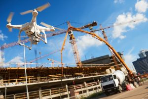
Unmanned Aerial Vehicles (UAR), or drones, are being used to scan areas for rapid modelling and to monitor projects, feeding back progress and change to site managers on a daily basis.
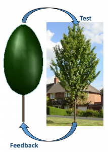
the design and asset model and the real object on site. In
the future, this bi-directional link will allow us to monitor
and respond to changes on site and consider modifications
to the feature and maintenance in a more informed and
planned manner.
New techniques in material engineering and fabrication are seeing greater use of off-site construction, where is it is cleaner and safer, and where 3D printing is moving from small, resin-based objects to large-scale construction. For example, MX3D is 3D printing a 12-metre long stainless steel pedestrian bridge to be installed across one of Amsterdam’s canals in the old city centre by late 2018!
The concept of a virtual model opens up new opportunities for digital realities in design, construction and management. Visualisation-based techniques, such as virtual reality (VR) and augmented reality (AR), will allow us to better understand what is to be built and also how it is to be maintained, while increased sensory feedback and artificial intelligence (AI) will allow us to learn and adapt better to change.
As Tom Wujic, states, we will move from estimating to knowing, from working with approximations to sampled reality and intuition will not be replaced but will be augmented. The result? Better informed decision making will, ultimately, lead to better performing landscapes that meet the client’s expectations and are fit for purpose.
Mike Shilton
Chair
Landscape Institute Digital Practice Group
Tel: +44 (0)207 685 2640
Twitter: @talklandscape


Evolution: Advancing digital twins in the AEC/O industry")


