With accidental cable and pipe strikes resulting in high costs, project delays and potentially life-threatening injuries, the Geospatial Commission has partnered with Ordnance Survey and the Greater London Authority to develop a National Underground Asset Register that will digitally map the world beneath our feet
Accidental strikes on the myriad of underground pipes and cables in the UK cost the economy £1.2bn a year. Workers who strike gas pipes and electric cables by mistake put themselves and others in danger of death or serious injury. But with no below ground base map to put utility companies on the same page when it comes to digging safely, the risk of asset strikes, project delays and disruption to the public remains high.
It’s the reason the Geospatial Commission, an expert committee formed to optimise the UK government’s use of location data, is doing something about it.
In collaboration with Ordnance Survey (OS) and the Greater London Authority (GLA), it is developing a pilot National Underground Asset Register (NUAR).
This neutral platform will pull in government and private data on the whereabouts of the UK’s cables, pipes, sewers and ducts to build a standardised digital map of assets under the ground.
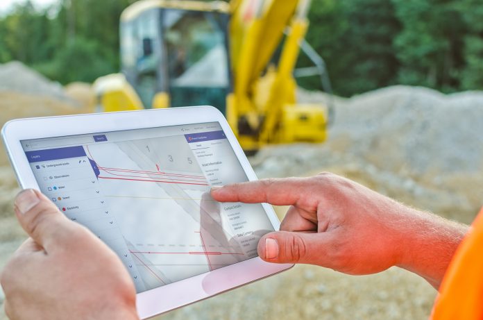
Users can then access the easy-to-use system via handheld devices in the field.
In 2019, the Geospatial Commission announced a 12- month pilot scheme to test how a NUAR could be designed and managed.
The commission chose two locations for the £2.4m pilot – London and the North East. The North East Underground Asset Register (NEUAR) was overseen by OS. The London Underground Asset Register (LUAR) was overseen by GLA.
OS’s strategic propositions manager, Carsten Roensdorf, worked on the North East trial.
He said: “The situation in Britain is there has been a lot of complicated underground asset networks built in this country in the last 100-plus years.
“While network operators have information about where these assets are, there are gaps in the data.
“More importantly, there is no central place for all this information to come together to serve use cases such as safe digging.
“For example, before commencing an excavation, you need to have access to all the records from all the suppliers or asset owners of a particular area, to inform you about the risk of what you might find if you dig a hole.”
Benefits
The benefits of an underground assets register would have a far-reaching impact on the utilities industry.
As well as helping users dig safely without striking a buried asset, it would help workers orientate themselves on site much easier, assist with more accurate and comprehensive planning to avoid delays, and allow asset owners to send and respond to data requests without having to maintain their own data response systems.
Roensdorf said: “What is really exciting for me is that we tried to approach solving a problem which has not been achieved before in England. And we managed to create a community in which we collaborated to solve the problem.
“It has been rewarding to see the reaction of people in the field, even guys who have been sceptical of new technologies are seeing the benefits and are asking ‘can I have this for my day job tomorrow?’”
Challenges
The trial proved a collaborative mindset and trust between all organisations involved, and the willingness to share data, is a must to make it a success.
There were three key challenges to overcome: on a cultural level, a legal level and a technical level.
Roensdorf said: “What we tried to make happen in the North East was to embed a culture of data sharing, where organisations who might be obliged to give information about their data become much more proactive in providing relevant information for the benefit of all.
“If everybody puts data into this data sharing scheme then you can do new things.
“You can improve and re-engineer business processes that have been in place for a long period of time. Mainly around safe excavations, which can be based upon rich, integrated information that wasn’t accessible before.
“You can make them a lot more efficient, a lot safer, and you can enable these facilities to provide a better service to their end customers through shorter disruption times.”
With regards to the legal side of things, the NUAR pilot addressed licences and liabilities that come with the use of the third-party data.
Every organisation puts their own terms and conditions and caveats onto the data they share.
Roensdorf said: “In the long run, it would be desirable to come up with a joint set of terms and conditions for most of the suppliers to sign up to.”
On a technical level, the challenges are around data quality issues. Data has been captured over many years with varying degrees of accuracy.
Roensdorf said: “The way we have approached this is to say we know there are issues with data quality, but that is not an excuse not to share data.
“We look at the data that is in NUAR, not as the definitive view of what is underground, but as the best possible intelligence of what might be there.
“The data providers have established the principle that even if we know the data is not perfect, we will share the data with the mindset that over time there will be continuous improvement in the quality of the data.”
One key feature of the trial was that it allowed feedback direct from the field. Workers on-site can contribute notes such as inaccurate locations or unidentified buried assets.
Roensdorf said: “We always start with the data when it comes to an excavation, but then there is the experience of the field engineer who will add more information and intelligence to it to make a safe excavation.
“We were lucky in the North East that everyone was quite open to the idea of sharing in this way.
“We hope that as the benefits of these continual updates are realised, it will encourage this behaviour to become more widespread across the rest of the country.”
Game-changer
Integrating the data on to a common map only works because all the utility companies already use a common base map to register their assets – OS Mastermap Topography layer.
OS was well placed to play the role of intermediary because all parties already relied on OS data above the ground.
Roensdorf said: “Utilities in the North East saw us as the trusted data broker. They were quite comfortable in sharing data with us and trusting us to distribute the data according to the terms and conditions that they set.
“Together with Northumbrian Water we brought the community together and proved we could create the technology to make this happen.
“We created the legal and security environment around it so everyone felt safe sharing data.
“This all aligned with the Geospatial Commission’s objectives to create an underground assets register.”
He added: “This can be a game-changer because it is essentially about digital transformation of utilities and local authorities’ operations and how they deal with infrastructure.
“They have access to all the other organisations’ data, which gives them better insight about the practicalities in areas, whether they are doing emergency works, replacement programmes or a new housing estate which needs to be connected.”
Carsten Roensdorf
Strategic propositions manager
Ordnance Survey
Twitter: @OrdnanceSurvey
LinkedIn: Ordnance Survey
YouTube: OSMapping













Having a digitised below ground base map that pulls in government and private data will safe the economy £1.2bn a year – another value addition to all -, with a far-reaching impact on the utilities industry, particularly the AEC sector.
The register seeks to close the gaps in the geospatial data as they relate to subsurface utilities with the hope of improving and re-engineering business processes, as well as guaranteeing personnel safety and protecting public infrastructural (buried) assets.
Trust the identified challenges of associated with the culture of data sharing, quality data with varying degrees of accuracy, and legality will be roundly addressed.
Smart surveyors and surveying and geospatial firms will readily leverage on the feedbacks from the ongoing pilot project and all the Commission is putting in place, and harness the professional and business opportunities therein/therewith.