
Drones are an invaluable digital/reality capture tool for the construction and infrastructure markets – but Ian Tansey of ProDroneWorx says the latest industry survey suggests they are not being used to their full potential
Construction companies are experiencing massive cost pressure, limited access to capital from financial markets or lenders and ever-tighter margins. In the UK, the average margin of construction companies is approximately 2%. This is unsustainable. Construction firms are starting to embrace change, technology and new construction methods to increase their margins. They are starting to embrace new digital technologies such as drones, BIM, data analytics and offsite manufacturing.
ProDroneWorx believes that the digital/reality capture data outputs created from drone technology using photogrammetry and LiDAR are starting to transform traditional business models, helping to reshape the construction and infrastructure markets.
This is happening through the improved management of assets digitally, deeper data insights, better collaboration on projects, improved data deliverables to clients, cost reductions and the reduction of risk.
Drones have a wide variety of uses, from 3D modelling (point clouds and textured models), topographical surveys, digital terrain models (DTM) and volume measurement to progress monitoring. Drone technology can be deployed quickly, safely and cost-effectively on any project to capture survey grade accurate 2D or 3D digital/reality capture information.
According to research from PwC, drone technology has the potential to increase UK GDP by £42bn (or 2%) by 2030. The research estimates there will be more than 76,000 drones in use across UK skies by 2030. The report finds that drone technology could help the UK achieve up to £16bn in net cost savings by 2030 through increased productivity.
These forecasts and the adoption of the technology were confirmed in a recent survey by my own company, ProDroneWorx. The use of digital/reality capture information from drone technology continues to increase, with 52% of respondents now using the technology compared with only 33% in 2017. Furthermore, 74% of those not using the technology plan on using it in future, so usage should continue to increase.
According to the survey, the top three reasons for adopting the technology are improved data quality (56%), time saving (54%) and the reduction of risk (42%). Interestingly, fewer companies than last year are planning on utilising drone technology in-house, reflecting perhaps the level of knowledge and expertise needed to deploy them.
ProDroneWorx believes that drone technology will transform traditional business models and help digitalise the construction industry. Indeed, those early adopters of the technology are starting to see a positive impact on their operational processes, from the way projects are monitored to the inspection of assets. The digital/reality capture outputs from drone technology can be used at all stages of the construction phase: planning, design, construction, and marketing.
Drone technology is one of the tools that can be used to produce digital/reality capture information, other methods include terrestrial laser scanning. The datasets from both the laser scanner and drone can also be combined to create complete accurate models of structures or objects.
Construction industry opinion on drones
Construction company Kier said: “The latest Prodroneworx survey demonstrates how far drone technology has progressed. Kier is working closely with Prodroneworx on some key projects to realise the benefits from drone technology, including progress capture, 360 photography and photogrammetry.”
Steven Hedley, vice-president technical at the CIAT, said: “As regulation and licensing laws surrounding drone usage tighten, it is imperative that specialist drone operators continue to facilitate the development of drone technology and its integration with Building Information Modelling (BIM) within our industry to maximise benefits and minimise misuse.”
Drone technology and BIM
The findings of this survey also demonstrate that drone technology is currently being underutilised. While 74% of respondents are using drone technology for photography and video, fewer than 30% of respondents are using the technology for value add services like aerial LiDAR, 3D point clouds, 3D modelling, digital surface/terrain models, orthophotos and thermal imaging.
The drone technology has many uses within BIM, for example:
- 3D Point Cloud: A survey grade, accurate 3D point cloud can be easily created for small or large areas, objects and structures with a drone using photogrammetry or LiDAR. The point cloud produced from a drone can also be combined with terrestrial laser scanning surveys to produce complete 3D point clouds. These models can be imported into BIM or CAD software so that comparisons can be made with the design models.
- 3D Textured Model: This visualisation solution allows users to understand more detail about their assets and uses contextual data to improve decision-making. The 3D models and the underlying point cloud data can be used to take measurements, plan future modifications and can also be brought into virtual reality (VR). These 3D models can be produced on various assets, eg bridges, commercial/industrial buildings, project sites, construction sites and infrastructure.
3D models bring the real world or “as-built” into the office and this means that the user can carry out a number of different tasks like: appraisal of existing conditions, monitoring construction progress, carrying out structural assessments and recording as-built conditions.
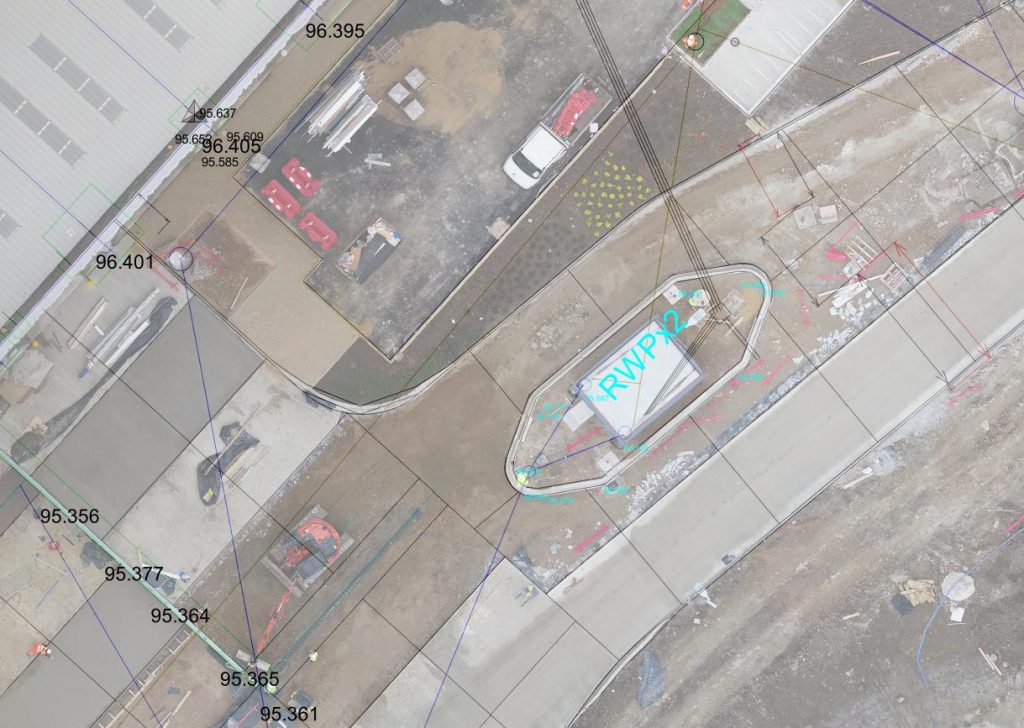
- Orthomosaics: These are a single, high-resolution digital image that is orthorectified so measurements can be taken from it. It can also be tied into the OS or a local grid using ground control points for global accuracy. A CAD model can be overlaid on it and it can be used in the following ways:
- In the project design phase to understand and plan the orientation of buildings, road, footpaths and services.
- For a planning application, it gives planners unique insights into the site and its surrounding area.
- Allowing developers to get critical aerial evidence to help support their planning case.
- Checking project progress against plan drawings.
In recent years, we’ve seen a lot of improvement in positioning accuracies through the use of ground control points (GCPs) or drones with RTK/PPK technology built-in, developments of photogrammetry software and the use of LiDAR on drones. 3D point clouds, textured model and digital terrain model (DTM) accuracies have now been demonstrated and validated down to approximately 3cm on some of our big infrastructure projects where fixed wing PPK drone technology has been used.
A key benefit of using drone technology, and the specialised photogrammetry software used to create the 2D/3D maps or models, is that the data can be imported into BIM, CAD or GIS software in different file formats, such as dwg, dxf, xyz, las, laz, obj and kmz. This makes integration of the digital 2D/3D data into workflow processes straightforward.
Ian Tansey
Managing Director
ProDroneWorx
Tel: +44 (0)7805 864642


Evolution: Advancing digital twins in the AEC/O industry")


