
Bentley’s BIM methodology provides an integrated solution to overcome hazardous topography
Rebuilding after a catastrophic landslide
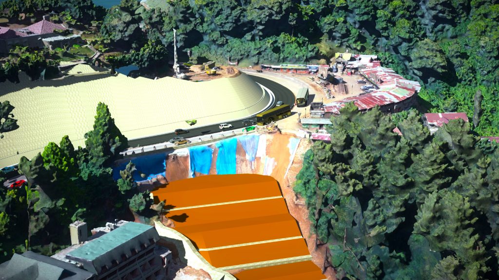
Indonesia’s Homecoming Festival symbolises the end of Ramadan, and since the country contains the largest Muslim population in the world, the event is significant. Three months before this annual celebration, a catastrophic landslide affected the road between Bogor and Cianjur, worsening the already terrible traffic situation on West Java’s main thoroughfare. The Ministry of Public Works initiated a quick remediation response and retained PT. Wijaya Karya (WIKA) to resolve the devastating impact and prevent future landslide occurrences in the area. The $2.9m (~£2.3m) BIM project required WIKA to perform a feasibility study for effective landslide protection while initiating reconstruction and preventive measures on a 407-meter-long stretch of the roadway.
The project site presented several hazardous geological and environmental conditions because it is surrounded by steep, sloping terrain and is affected by heavy rainfall. In addition, the road is heavily travelled and offers a limited work zone. Therefore, the government imposed a tight five-month schedule to minimise traffic disruption and accommodate the timing of the festival. Faced with potentially dangerous and complicated site conditions and a short timeline, WIKA needed to perform design and construction tasks simultaneously. Recognising that a traditional design approach would fail to meet these challenges, WIKA implemented a digital strategy for data capture, design, and construction management, using Bentley’s integrated BIM and reality modelling applications.
Leveraging reality modelling
WIKA properly investigated the project site using unmanned aerial vehicles coupled with ContextCapture to capture images, perform ground extraction from the reality mesh, and produce a digital terrain model that provided an accurate representation of the existing site. The reality modelling software facilitated a digital survey of the 12.8-hectare area with clear visualisation to help with site security management and fieldwork optimisation. This survey methodology alleviated the risks associated with manual data acquisition amid the hazardous landscape.
Using the aerial drones and Bentley’s reality modelling application enabled the team to complete the entire data capture and digital terrain model of the existing site within one day compared to one week using conventional methods. WIKA maximised the captured and modelled site information, eliminating the need for on-site surveys, ensuring personnel safety, and optimising roadway design relative to the actual site.
Integrating Bentley’s interoperable BIM technology allowed WIKA to leverage data directly from the ContextCapture reality mesh to design a 3D model of the landslide protection elements within 10 days compared to one month using traditional modelling methods. The team identified the location of the nearby river and analysed constructability in real-time to reconfigure the pier design and determine a solution that avoided disturbing the natural river channel.
A connected data environment
WIKA established an open, connected data environment based on ProjectWise® that improved collaboration and streamlined workflows among stakeholders to reduce project design time by 30%. The integrated connected data environment accelerated information exchange to resolve typical data sharing and delivery issues among the multiple engineering disciplines and between the field and offices.
The team used ProjectWise to coordinate and manage files shared among multidiscipline teams, simplifying file sharing and design modification between the office and field engineering. Navigator allowed field engineers to review the 3D model and receive real-time updates and material quantities information as a result of design changes. The integrated project delivery platform facilitated better project coordination and accelerated reliable information exchange from field personnel to identify and resolve potential costly issues on-site. Working in a connected data environment, with cloud-based support through Bentley CDE design capabilities helped manage deliverables, capture field data, and share files. The dispersed team effectively collaborated and supported work processes to seamlessly progress and keep the project on schedule.
Digital design applications optimise efficiencies
Bentley’s integrated BIM technology provided WIKA with an effective digital solution that reduced project risks and difficulties during construction to achieve the tight reconstruction schedule. The team used PLAXIS® to analyse and report on geological conditions and perform structural calculations to ensure the reconstruction design was capable of withstanding future landslides. Based on those calculations, the team used OpenBuildings™ Designer (formerly AECOsim Building Designer), OpenRoads™, and ProStructures to model the site, roadway corridor, and ancillary structures. OpenRoads helped optimise structural design and geometry of the roadway while OpenBuildings Designer facilitated production and management of 2D and 3D drawings as well as enabled construction sequencing and scheduling. The interoperability and automated capabilities of the applications provided accurate quantification of concrete volumes and material quantities to save 20% in construction costs.
Adopting a 3D building information modelling (BIM) approach using Bentley’s applications optimised efficiencies, enabling basic design for roadway reconstruction to be finished in approximately two-and-a-half months. The software allowed design and construction to occur simultaneously to accommodate the strict timeline and finish the temporary road construction five days prior to the festival. Providing a digitally integrated modelling environment, the design applications saved $660,000 in design costs, accelerated design and construction time by 30% to save three months, and improved overall quality by 95%.
Romi Ramadhan, BIM manager at WIKA, said: “With a digital approach, we can optimise costs, speed up the project schedule, and get an accurate design.
“Bentley’s BIM solution is the right one to face the challenges.”
Success drives future digitisation
Restoring and improving a devastated, landslide-impacted roadway that is part of the National Highway system of Indonesia and links two heavily populated areas was a monumental task for WIKA. Fulfilling the project within the strictly imposed, tight timeline demonstrates to the government that WIKA is capable of delivering extremely critical projects. Using a digital project delivery strategy for this project can provide future tangible benefits to the Indonesian government, extending digitisation to its asset maintenance and management. Apart from reducing traffic density, digitisation will provide a safer, more reliable roadway system, enhancing regional quality of life.
Implementing a digital approach using Bentley technology allowed the team to confidently and safely capture and model the necessary data and deliver a better project in a shorter time.


