As planning and building teams seek to improve efficiencies and cut costs on projects, Sven Van Duffelen, from 3D mobile mapping and monitoring specialist GeoSLAM, looks at how technology is enabling a growing number of developers to prioritise energy efficiency in new housing developments
According to the Home Builders Federation, homeowners in new builds can now save average of £629 per annum in energy bills – a sign of just how far new developments have come in recent years. Added to that, a staggering 80% of properties built today have an A or B rating for energy efficiency, whereas only 2% of older homes have a comparable rating.
Passivhaus is one example of a scheme enabling these changes. Popular across Europe, Passivhaus buildings provide a high level of occupier comfort, while maintaining the gold standard in energy efficiency – similar to the Minergie-P standard building in Switzerland.
Highlighted at last year’s Passivhaus Conference in Munich was the increasing availability of certified components, resulting in this type of property becoming much more sought after by both local authorities and buyers on the private market.
As the aspirational standard in housebuilding for the future, there are currently just 65,000 buildings with the certification worldwide, a figure set to increase as local authorities and housing associations across the UK begin to see the benefits of aiming for Passivhaus standard.
A notable example is Norwich City Council, which is on course to deliver 112 certified homes at its Rayne Park development in 2019. According to the council’s chief executive, the scheme is designed to help alleviate fuel poverty for tenants while generating revenue, replacing housing stock lost through Right to Buy, and ensuring compliance with the authority’s environmental strategy.
But how do more councils and local authorities reach this aspirational standard? In a bid to increase the production of Passivhaus builds and reduce costs, improve build productivity and facilitate better communication between stakeholders, developers have been turning to Building Information Modelling (BIM) software.
Evolution of design
The benefits of BIM are widely recognised, from its ability to create early design prototyping and minimise wastage to its potential to encourage collaboration between stakeholders. BIM also helps to alleviate the pressure on surveyors, who were once required to spend days recording building measurements.
Integral to the rising adoption of BIM are advances in handheld 3D laser scanners and associated processing software, which together have enabled organisations and professionals from a wide range of industries to access the technology more easily and, crucially, within the standard of high-spec environmental accreditation.
Using handheld 3D mobile scanning technology, surveyors have the potential to quickly re-scan a site at various project stages, providing a digital update that can help teams identify problems in advance. Some handheld mobile scanning devices also have the advantage of real-time scanning. The ZEB-REVO RT, for example, has the additional advantage of enabling surveyors to check that they have a complete scan of an area before they leave the site, avoiding the time-consuming process of returning to map a site again.
While the final aim of both Passivhaus and Minergie-P standard builds is to produce a comfortable and energy-efficient home as a final product, it’s equally important to consider the process through which the property is built. Developers must remain conscious about energy wastage, time consumption and cost increases during the construction and design phases in order for these builds to truly reflect their ‘eco’ purpose – a standard the Royal Institution of Chartered Surveyors (RICS) demands from residential property developers.
Benefits of SLAM technology
Construction projects today often require regular surveys to generate new models as the development takes shape. One issue with static scanners is that they take time to set up and usually require an experienced operative. Handheld scanners can make the process quicker, but since many rely on GPS, these devices are not effective once the building has been constructed and measurements are needed in enclosed or underground spaces.
One alternative that can support quicker adoption of BIM is a mobile mapping tool that uses Simultaneous Localisation and Mapping (SLAM) technology. First developed in the robotics industry, tools using SLAM are capable of scanning indoors or other difficult-to-reach, enclosed spaces. Using information from sensors, normally LiDAR and imagery, digital 3D maps can then be created based on the location of the device, without the need for GPS.
SLAM-enabled lightweight scanners, such as GeoSLAM’s ZEB-REVO or ZEB-HORIZON, can allow surveying teams to map and monitor sites on foot or with UAVs (unmanned aerial vehicles). As a scheme takes shape, any member of the site team is able to pick up a handheld 3D mobile mapping device and with a ‘walk and scan’ method of data collection, capture and process data in hours and minutes, rather than days and weeks. This not only saves time throughout projects but also reduces the risk of injury when operating in potentially hazardous build locations.

SLAM technology in action on multi-phase projects
One such example of this technology in action is a recent project with sustainable home developer Blueprint. Delivering an ambitious 450-home scheme at Trent Basin on the banks of the River Trent in Nottingham, GeoSLAM was invited to scan one of the completed Phase 2 properties.
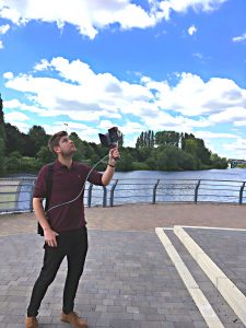
Ashley Walters, Blueprint’s development manager, used a ZEB-REVO to scan one of the buildings, and discussed how SLAM technology could assist eco-home projects.
“Working on high profile, long-term developments with dozens of stakeholders is an incredibly complex process. These projects can take many years to complete, especially if the environmentally-friendly specification is high or there are multiple phases such as with our Trent Basin scheme. Relaying data and measurements to every single organisation involved has historically taken us a long time,” he explained.
“We’ve never used a SLAM-enabled tool before, but I was surprised how quickly the ZEB-REVO scanned the entire property – just eight minutes! This would usually take at least a couple of hours with traditional surveying tools for just the one property, which is arduous given how many properties we will be building across the entire development.
“For developers, the data-sharing element of 3D mobile mapping tools using BIM is really valuable. Whether it’s checking measurements with architects to make sure their plans are adhered to, providing detail to our estate agents to support their bid to sell properties, or indeed the new owners who want updates on the build process – I fully acknowledge how 3D mobile mapping devices such as those from the GeoSLAM ZEB family will become ever more important in the sustainable developer market.”
Conclusion
As the popularity of Passivhaus and Minergie-P standard continues grow and both commercial developers and local authorities turn to eco-friendly driven systems, the need for the technology to support these schemes is only set to rise. With wider concerns from both the public and private sectors focused on reducing cost, meeting complex specifications and dealing with various stakeholders, tools such as 3D mobile mapping devices with SLAM will play a vital role in helping the construction sector to overcome these challenges.
No matter the size of the project or deadline, the speed and simplicity of these devices will prove crucial to hitting deadlines, meeting build guidelines and regulations and, of course, enabling developers to stay on budget.
Client: Blueprint & Nottingham City Council
Location: Nottingham
Project Team: Willmott Dixon, Marsh Grochowski, Gleeds Structural, BWB Consulting, GeoSLAM
Completion: 2019
Sven Van Duffelen
UK Channel Manager
Tel: +44 (0)1949 831 814
Twitter: GeoSLAMLtd
LinkenIn: geoslam


Evolution: Advancing digital twins in the AEC/O industry")


