Space technology piloted in Leeds is helping to make homes more energy efficient
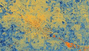
A specially equipped plane mounted with a thermal imaging camera flew over Leeds to capture data revealing insights into how much heat was being lost from the buildings below.
According to the Leeds Climate Commission, around a quarter of the city’s carbon footprint comes from the energy used to heat and power residential buildings.
Poorly insulated roofs, walls, and windows are common culprits of properties losing heat.
The thermal imaging camera, developed by Satellite Vu, can help identify the ‘leakiest’ buildings in a large area.
Information can then be used by local authorities to target and prioritise funding for homes most in need of energy-saving green upgrades.
Data collected from the Leeds pilot will be used to inform the work the council is undertaking as part of the ‘Net Zero Homes Plan‘.
The council intends to use insights from the test to help residents better understand the thermal efficiency of their properties and to motivate retrofitting in the private sector.
It will also use the data to help secure more funding for local area-based retrofit projects.
The ‘Holbeck Group Repair’ scheme saw around 300 of the city’s coldest and oldest homes receive a ‘whole house’ package of energy-saving upgrades, including new roofs and external wall insulation – cutting energy use by 25-30%.
Councillor Helen Hayden, executive member for Infrastructure and Climate, said: “This is an innovative project that could transform our understanding of building heat loss at the city level, potentially unlocking additional investment in energy efficiency measures that cut energy bills and help us tackle climate change.”


