
The latest Data Insights Report from Landmark Information examines the history and origin of land contamination across England and Wales. Senior consultant Piers Edgell discusses the importance of data in mitigating risk and due diligence decisions
The United Kingdom is a small island where the land, since the 1700s, has been used intensively. If we look back through history, we can see that land use has changed across the country, from agriculture to industry, commerce or residential – the uses have greatly varied.
As land is therefore redeveloped or repurposed, it is important to be able to peel back the layers of history to identify former land uses. Past industrial processes, waste disposal practices, military activities and accidents, for example, may have released substances on or in the land that has the potential to harm human health, damage property, impact ecosystems or pollute coastal, surface and groundwater.
While sources of land contamination vary greatly – with some cases naturally occurring from substances such as radon, arsenic or lead – much land contamination has derived as a result of past man-made industrial activities.
It is a legacy of former industrial works, processes, spillages or waste disposal that could have a real impact on plans to develop or redevelop a site. With more development projects taking place across designated brownfield sites, the risk of discovering contaminated land is potentially higher. While in most circumstances the associated risks are relatively low, there is the potential that it could present a risk, depending on what the contaminant is.
According to Part 2A of the Environmental Protection Act 1990 (the key legislation for dealing with contaminated land) and the Environmental Damage Regulations, just because land may be affected by contamination, doesn’t necessarily mean it is considered “contaminated land”.
Three main components must be identified for it to be classed as such:
- The existence of a source of contamination.
- A receptor (ie a household).
- A pathway between the source and the receptor.
Before embarking on any development project, it is essential that the correct due diligence is completed to map out any possible risks – and to determine what it means, and legally, what needs to be done to mitigate any potential risk.
The starting point is information gathering and research, using historical mapping data, council registers, planning history, and site-specific reports on investigation and remediation.
It’s important to note that identifying that a plot of land may be affected by contamination does not mean your project is a non-starter. It does, however, mean that a strategy must be implemented to manage any potential risks, as responsibility ultimately lays with the developer.
Gathering the right data upfront will therefore determine the risk levels so appropriate steps are taken.
Today there is a wealth of online geospatial data that helps to mitigate risk, while also enabling due diligence decisions to be made faster.
Understanding the health of land and property is paramount in making those decisions, therefore having the ability to accurately assess historic (and current) land use is increasingly essential when it comes to managing our land use as it continues to evolve.
Data insights: A snapshot
Landmark Information publishes a regular Data Insights Report for property and land professionals; the latest edition delves into the history and origin of land contamination across England and Wales.
The report provides an insight into land contamination risk that is today regulated under Part 2A of the Environmental Protection Act 1990. It looks at the areas across the UK with the most Recorded Landfill and Potentially Infilled Land sites, as well as looking at some example Historic Land Use datasets and naturally occurring land contaminants.
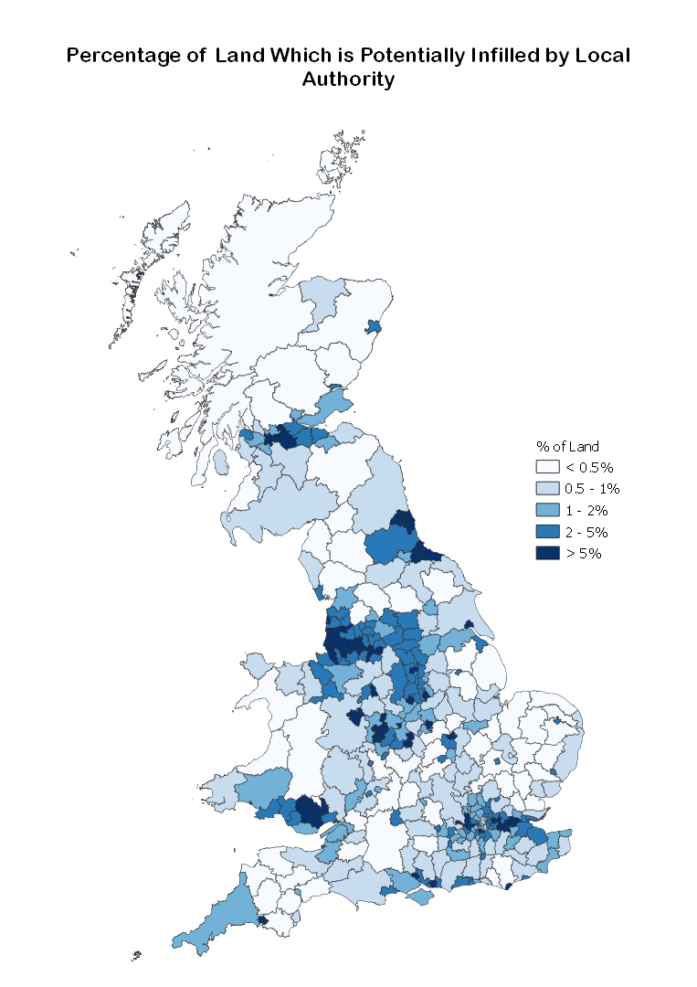
Recorded Infilled Land Sites
The report offers an insight into the percentage of land, by local authority, which is covered by a recorded infilled site – as identified from historical Ordnance Survey mapping. It found that 13 local authorities have 10% or more, as follows:
- Blaenau Gwent County Borough Council – 18%
- Kingston upon Hull City Council – 17%
- Sandwell Metropolitan Borough Council – 16%
- Stoke-on-Trent City Council – 16%
- Wolverhampton City Council – 15%
- Dudley Metropolitan Borough Council – 14.5%
- London Borough of Newham – 14%
- Southampton City Council – 12%
- Blackpool Borough Council – 11%
- Walsall Metropolitan Borough Council – 11%
- Manchester City Council – 11%
- Wigan Metropolitan Borough Council – 10%
- Cardiff Council – 10
Data analysis: Historical land use
Typically, land contamination is associated with past industrial activity whereby harmful substances may still be present and pose a potential risk. With any land identified as having a historical works usage, the expert view of an environmental consultant would determine if it presents a potential Part 2A risk.
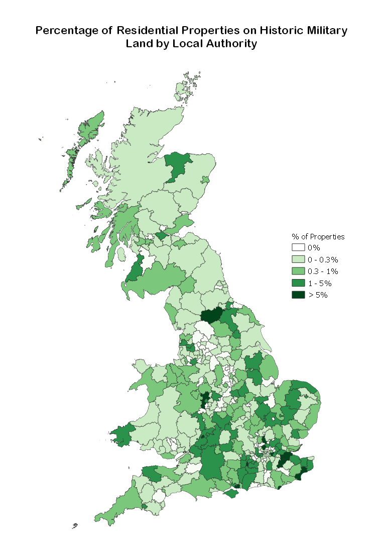
One example of historical land use where internal risk models and further investigation into land usage and Part 2A risk would be recommended prior to development is military usage. It is, however, important to state that many types of military land usage would not cause a potential contamination issue.
Here, we looked through our historical “military land” data to consider the percentage of both residential and commercial properties that are today located in these areas:
There are six local authorities where more than 10% of their total residential properties are located on historical military land.
- Gosport Borough Council – 23%
- Eastbourne Borough Council – 13%
- Richmondshire District Council – 12%
- London Borough of Greenwich – 12%
- Rushmoor Borough Council – 11%
- Portsmouth City Council – 10%
Commercial
- Gosport Borough Council – 27%
- Rushmoor Borough Council – 19%
- Portsmouth City Council – 13%
- Medway Council – 13%
- Fareham Borough Council – 9%
The total UK land holdings for the Ministry of Defence (MoD) was reported to be over 344,200 hectares, as of 1 April 2021. This compares with 432,900 hectares in 2013 – a reduction of over 88,700 hectares – or 219,182 acres. A proportion of this land will have been redeveloped for residential or community purposes.
To download a copy of the Data Insights: Land Contamination report, visit the Landmark Website.
© Landmark Information Group Limited and/or its Data Suppliers 2021
Ordnance Survey © Crown copyright and/or Database Right.
All rights reserved. Licence 100022432
Contains OS data © Crown copyright and database right 2021
Piers Edgell

Senior consultant
Landmark Information
Tel: +44 3300 366000
Twitter: @LandmarkUK
LinkedIn: Landmark Information Group
Youtube: LandmarkUK


