Aecom explains how GIS digital delivery has increased collaboration and reduced costs on Scottish Water projects
As a data-driven industry, one of the key enablers to successful implementation and take up of new digital workflows is ensuring that users feel they get two benefits – speed and simplicity.
Achieving simpler and faster project delivery, with no compromise on quality and health and safety, are two of the aims driving Caledonia Water Alliance (CWA), a joint venture between AECOM and Morrison Water Services. CWA works on multiple projects per year for Scottish Water in its role to support the delivery of the client’s water and wastewater infrastructure element of its capital investment programme.
Building Information Modelling (BIM) compliance and digital delivery are a hugely important part of the work, and the team has now started to see the rewards of taking its digital approach further through the use of GIS digital delivery.
GIS and BIM data have been integrated into a single web viewer
Working collaboratively, the team drove the implementation of CWA’s BIM processes, ArcGIS Online, ArcGIS Field Maps and ArcGIS Pro, and took the native integration steps to include Autodesk technology, meaning that GIS and BIM data have now been integrated into a single web viewer.
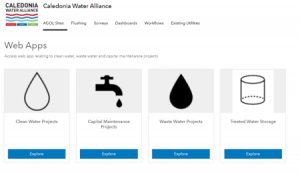
The result is that all projects on the six-year framework have access to a project ArcGIS Online (AGOL) site, which can host project information across all disciplines. Design data, Scottish Water assets, site surveys and photos, land liaison information, construction and as-built information can all feed into a project’s ArcGIS Online site. The information can be viewed via the web using a laptop, tablet or phone.
Once a project AGOL site has been created, there’s a standard set of information which is automatically included in the project’s map, such as existing clients’ assets, existing SGN data, Scotland National Heritage protected sites, Historic Environment Scotland sites, BGS Geology and Boreholes and Coal Authority information.
Design content or additional third-party content can also be published to the project AGOL site. This information includes proposed alignments and location of valves and manholes (from Civil 3D), proposed plan layouts (location of pumping stations, DSRs), SI information and existing land owner information.
Project AGOL sites also have Editor Tools for users to manually add information to the site. The intention of the developed tools is to help create proposed routes before requesting additional resources to create drawings. The outline designs created on the AGOL can be consumed directly into Civil 3D and then be developed to Detailed Design.
 Reducing time and improving accessibility
The AGOL sites have how brought proven efficiencies. They ensure existing constraint information is instantly accessible and it reduces the time taken to collate information. It has improved projects so they develop quicker and ensures all projects are using consistent data.
For both the JV partners and the client, collaboration has increased. All parties can access data more easily and less resource is needed as the need for manual handling of data is reduced. In addition, the delivery process is sped up as some traditional drawings, such as the as-built drawings, are no longer needed – all the data is in the GIS environment and now consumed automatically by the client.
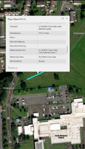
On site, the GIS digital delivery also brings benefits. Teams now use ArcGIS apps to complete surveys and view GIS data while on site. All surveys and data collection are published to the projects AGOL site. Once the data has been captured, dashboards can be customised to view the data. Live construction progress is now being reported by integrating project data with PowerBI. Daily tracking is now being viewed by the planning team, removing manual updates required by the site team.
ArcGIS Survey123 is a simple and intuitive form-centric data gathering solution enabling users to create, share and analyse surveys and share across projects.
ArcGIS Field Maps is an all-in-one app that uses data-driven maps to help mobile workers perform data collection and editing, find assets and information, and report their real-time locations. ArcGIS Field Maps streamlines the critical workflows field personnel use every day. Because it is built on ArcGIS, everyone – whether in the field or the office – will benefit from using the same data.
Construction processes have seen major benefits from digital transformation
Since the introduction of GIS over the last 12 months, design, construction, health and safety, land liaison, planning, customer and performances are now benefiting from the digital transformation. CWA now has over 100 users from viewers to field workers accessing and recording digital content, over 9,000 digital surveys have been completed and the client has access to view project content and consume data. The culture of producing and sharing project information continues to evolve throughout the remaining of the six-year framework.
David Dukes
Associate
Aecom
Tel: +44 (0)20 7061 7000


