
Marc Zschieschang, software product marketing manager at FARO Technologies, examines the growing use of 3D laser scanning to ensure safety and efficiency in the oil and gas sectors
From field to finish, every opportunity to reduce risk and error has impact. That’s why accuracy and safety are paramount at every stage of oil and gas exploration, production and distribution. Imprecise measures can produce safety issues or create scheduling problems that delay projects and increase costs.
“When things don’t fit in an environment where processes are hot, lines could snap and guides could break – it could be catastrophic,” says Mark Franklin, design and reality capture lead for Kleinfelder, an engineering, construction management, design and environmental professional services firm.
“Even if nobody gets hurt, it’s very expensive to change field welds and cuts. Delays and safety violations also result in expensive fines.”
To counteract these challenges, many oil and gas companies are adopting 3D laser scanning. Not only is the technology fast and efficient, the digital record generated easily proves cost savings. Thus, when applied to the oil and gas industry, there are numerous advantages.
8 ways 3D laser scanning benefits process plants
Modelling with process plan: 3D laser scanning allows operators to quickly and accurately model in the point cloud, which is particularly important when performing conversions. Consider tie-in flanges on a pipe. In that example, you must know exactly where that is down to a sixteenth of an inch.
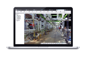
The way it works is simple: operators pick two points on the scanned pipe and the software algorithms analyse the shape of the cylinder and determine the size of the pipe run. The FARO As-Built™ software then models on the pipe using the predefined specification. Once the piping run is complete, it can be converted to solids.
Precision deployment: Scans uncover issues before your team can. Franklin explained that in one instance, his team analysed some scans on behalf of a client and noticed that fireproofing was falling off. With that information, the client’s crew knew exactly where the issues were and deployed to those locations without manually inspecting the entire facility.
Planning: Laser scan data is valuable for planning maintenance, construction or decommissioning activities. For example, one frequent problem is fitting large equipment into an existing plant. Accurate drawings need to be reviewed but, in many cases, the original plans don’t show upgrades and changes. With laser scanning, you can take a point cloud, run a quick animation and deploy clash detection to guarantee the equipment will fit in advance of the project.
Plant maintenance and expansion: It can be impossible to know exactly what’s in a processing plant, drilling site or pipeline facility before maintenance or expansion activities.
“We had existing drawings of a 42-inch line about three storeys up that needed to be replaced,” Franklin recalls. “After the scan, we could see it was six or seven inches off. Our engineers did a stress analysis and looked back at construction records, and realised the crew put on come-alongs to pull piping over. That allowed us to warn them that the pipe could spring when unbolted, which could result in serious injury.”
Large-part inspection: Consistent, accurate measurements are critical to maintaining design intent and performance of plant equipment but it can be time-consuming and dangerous if done manually. Laser scanning takes precision measurements that minimise user variability and eliminates rework and scrap.
Decommissioning: Phasing out drill pads, pipelines and plants is a time-consuming project requiring extensive documentation and verification. Handling the process efficiently is more important as the industry’s infrastructure ages. Consider the situation in Alberta, Canada, where about 100,000 individual well pads will soon need to be decommissioned. Once the project is underway, scanning can help owners and contractors document the entire process. And with environmental agencies watching these remediation projects closely, detailed documentation is key. It’s a lot of work to do that manually. But laser scanning can get the job done in only a few hours.
Regulatory verification and documentation: Because 3D laser scanning creates an accurate digital representation of a site or project with a point cloud and photos, there’s an added layer of verification. A company can show regulators what is there before they inspect
Operator training: Given all the data the scans generate, a company can create a virtual model of the entire plant to train employees.
“We worked with a gaming company to animate our scan data so operators can go through and feel like it’s real life, not a game. They feel immersed. You can even see rust on a railing,” Franklin says. “We never thought we’d be doing that.”
Fuelled for success
With so many applications for 3D laser scanning in oil and gas deployments, it’s clear that now is the time to embrace the technology.
“I know some firms have been reluctant to adopt laser scanning, but it’s the way of the future,” Franklin notes. “If you’re not doing it, you’ll be left behind.”
Tel: +49 (0)7150 9797 – 400
Twitter: @Faroeurope
Please note: this is a commercial profile.


