")
How the liquid storage petrochemical industry is wising up to its growing potential using 3D laser scanning. By Matthew Davies, account manager, FARO Technologies
Around the world today, the storage of liquid fuels and other petrochemicals is no easy task. For starters, it’s imperative that the storage facilities operate within established specifications and that their as-built designs match original blueprints.
One of the ways to ensure this is through a piping and instrumentation diagram, or P&ID, a compliance document that identifies all process equipment and how these physical assets work together.
Traditionally such diagrams were generated via manual measurement necessitating a team of surveyors measuring a facility’s assets by hand. The work involved significant health and safety risks, costing both time — and money.
Recently that’s begun to change.
The ABCs of P&ID
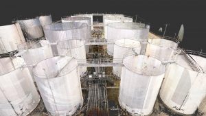
Now, 3D laser scanning and its related software applications are aiding this process. In summer 2020, UK-based Advanced 3D Laser Solutions Group (A3D), along with their US partner HTS Advanced Solutions, 3D laser scanned a large liquid storage terminal in Houston, Texas, with the goal to generate more accurate 2D P&IDs from 3D scan data. To achieve this task, the companies relied on two FARO® Focus Laser Scanners and FARO SCENE Software.
“The Focus Laser Scanner was chosen because of its data capturing speed, portability, which was key for scanning in tight spaces, its ruggedness in different areas of site and consistent clear images which would be key for our CAD team in developing P&IDs,” explained Lewis Boxer, A3D’s technical director. “The scan data was processed in SCENE because of its compatibility with the Focus scanners and its variety of built-in clean up filters such as edge, range and stray point.”
Digital diagramming delivers
The Houston facility, part of the Americas division of the Netherlands-based Royal Vopak, boasts a storage capacity of 1.2m cubic metres across 243 tanks.
Vopak had already retained a company to perform a manual survey but feared the partially finished project would take years to complete. As a result, Vopak sought out A3D in partnership with its US subcontractor to complete the 3D laser survey.
After each shift the scans were uploaded via SFTP directly to the A3D server allowing for the UK-based team to complete scan file registration, including the filtering and processing. This process ensured they could report any missing data to the survey team ahead of the next scan shift. The survey was completed in three months with a total of 5,136 scans. Instead of taking the two to three years to finish using traditional surveying techniques, A3D completed the project in just 10 months.
To work as efficiently as possible, A3D planned individual aspects of the job to run concurrently wherever possible. For instance, once an individual area was scanned and registered, they were converted immediately, ready for the CAD team to start building the P&IDs before returning to HTS for field validation and client team for remote E&I updates. It was only then that they were handed over to Vopak in their as-built form.
The entire process was streamlined so that scanning was prioritised to align with the order in which P&IDs were to be delivered, starting within days of the first recorded data. Running a project that amounted to over 650 P&IDs required detailed tracking which A3D achieved using specialist project planning personnel and software. The results were shared with key client stakeholders during weekly progress meetings.
For each area, a drawing template was built, which sped up the process of building the subsequent P&IDs for that area and maintained a user-friendly, consistent standard. The laser survey provided ample detail for A3D to create everything except remotely connected instrumentation, which would be added from Vopak’s existing P&IDs, DCS panels or existing wiring diagrams.
Hardware and software go hand-in-hand
The ultra-portable and rugged Focus Laser Scanner was ideal for Vopak’s needs specifically because it is designed to capture ultra-high accurate measurements of equipment and pipework in challenging outdoor environments. The scanner features a sealed design and is certified with the industry standard Ingress Protection (IP) Rating, IP54, meaning it can be used in wet weather and up to 131°F.
But for all the time and budget savings a project like this achieved in the short term, the greatest benefit might come in the future.
That’s because Vopak (and companies like them) are increasingly reliant on this form of imaging versus photogrammetry to gather the surveying data they need to secure a complete 3D survey of their site. This is a highly accurate and precise dataset that can be used for many ancillary projects including: API570 inspection isos, tank verticality, bund volume analysis and as-built 3D process models. It could even be used for mapping plant design, or complete facility upgrades.
“It’s not just the initial projects you’re paying for,” Lewis Boxer added. “It’s the other continuous deliverables that are born out of it.”
Tel: +49 (0)7150 9797 – 400
*Please note: this is a commercial profile


